A land parcel can look perfect on paper and still be wrong on the map. Its record may list the right owner, the right area and the right land use, yet its boundary quietly overlaps the neighboring plot or sits several meters away from where it should be. Vietnam is now hunting down exactly those hidden errors at national scale, using satellite imagery, drones and GeoAI.
Few datasets matter more to daily life. Land records underpin ownership certificates, compensation when the state recovers land, urban planning, infrastructure projects and a large share of civil disputes. When the underlying database is inconsistent, every one of those processes slows down or goes wrong. Cleaning it is therefore not a back office exercise but a foundation for how the country manages its most contested resource.
A nationwide cleanup with two government plans
The push is structured by two joint plans. Plan 515/KH-BCA-BNN&MT, issued on August 31, 2025 by the Ministry of Public Security together with the Ministry of Agriculture and Environment, opened a 90-day intensive campaign to enrich and clean the national land database, with data synchronized centrally and connected to the national population database.
Plan 2959/KH-BNNMT-BCA, dated March 29, 2026, goes further, pushing surveying, cadastral mapping, land registration and cadastral record keeping so the national land database can be completed. The stated criteria are demanding: land data must be accurate, complete, clean and up to date, as well as unified and shared across agencies.
Complete on the form, wrong on the map
The hardest problems are spatial, not textual. Data can be complete in every attribute field and still hide overlapping parcels, shifted positions or missing links between a plot and its legal file. Cleaning therefore has to cross-check three layers at once: the attributes, the legal records and the geometry of each parcel.
Two workstreams run in parallel. The first cleans and completes data accumulated over many historical periods. The second builds data from scratch for parcels that have never entered the system. Reviewing millions of parcels by hand, one file at a time, cannot keep pace with either task, which is why the review itself had to be automated.
Three layers of observation
The technology chain starts from orbit. Satellite imagery watches wide areas and tracks how land use changes over time, revealing where the current state on the ground no longer matches the stored record. Satellite positioning supports precise survey coordinates, while UAVs add fine detail in priority areas where satellite resolution is not enough to draw conclusions.

Combining the view from above with field surveys lets agencies identify change accurately and choose the right areas to verify, instead of spreading scarce survey teams everywhere at once.
Inside VNPT iLIS
The platform tying the workflow together is VNPT iLIS, a land information system developed by Vietnam Posts and Telecommunications Group. It manages cadastral data, change registration, certificate issuance and file circulation, and integrates GIS mapping tools for displaying, searching and editing parcel boundaries, with interconnection to other systems.
VNPT iLIS has been deployed in provinces and cities including Quang Ninh, Gia Lai, Dien Bien, Lai Chau, Lam Dong, Can Tho and Phu Tho. In this model it acts as the environment that receives, processes and maintains the data, while an end-to-end workflow management module manages each job from data intake and checking through to completion and handover of standards-compliant data into the system.

GeoAI flags the anomalies, officials decide
GeoAI sits in the spatial review step. It automatically analyzes imagery and maps and flags three kinds of anomaly for officers: parcel boundaries that cross each other, groups of parcels shifted from their true position, and parcel boundaries encroaching on transport infrastructure.
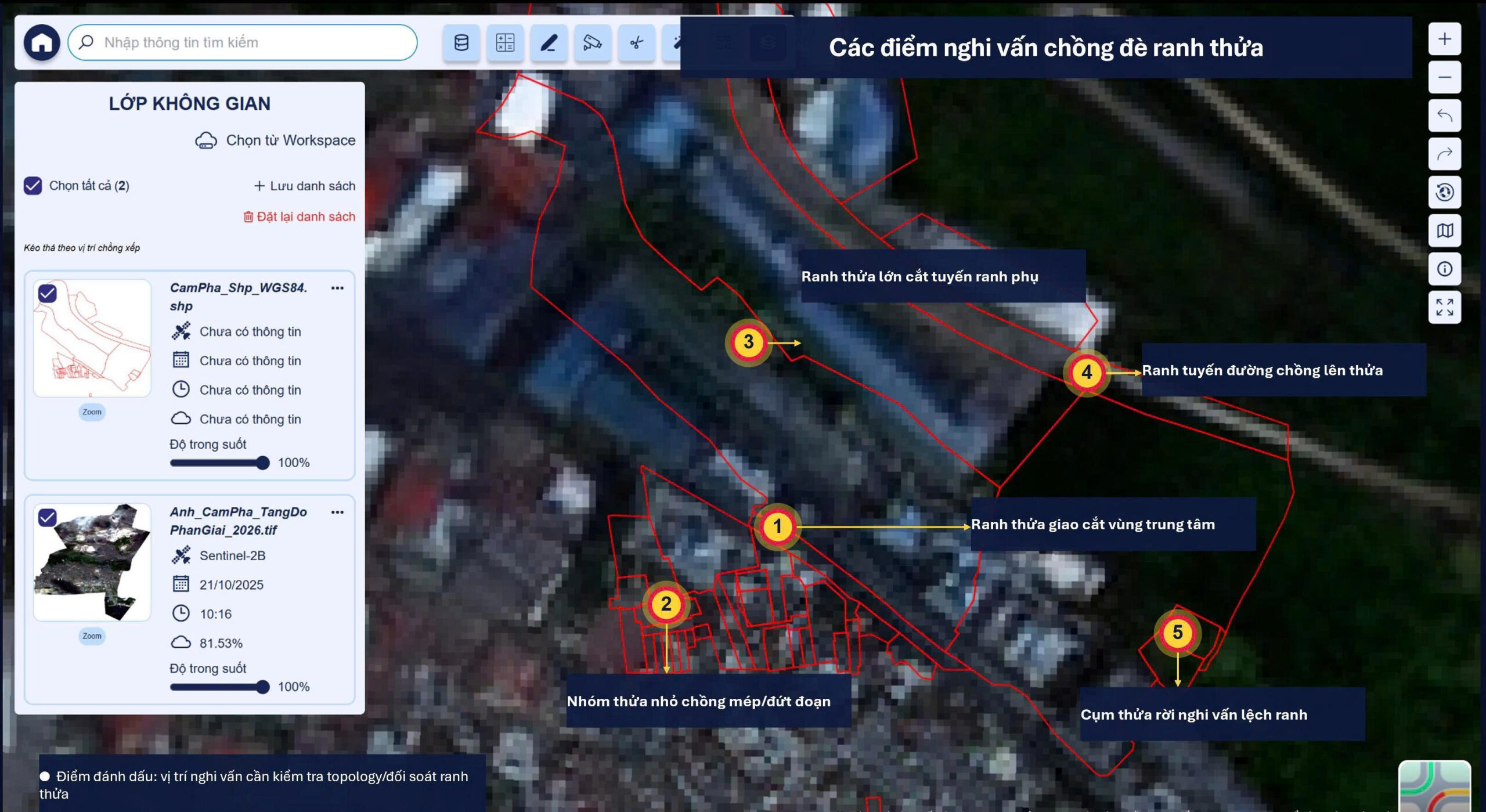
Every flagged case is then verified by cadastral officers against the legal records. Boundaries are edited according to the verification result, and the system stores the full processing history for each case, including the responsible person, the status and the legal basis added along the way.
VNPT is explicit about the limits of the technology. Information drawn from imagery only supports the review; the legal status of a parcel, and any violation, must still be appraised and verified strictly in accordance with the law. The technology works as a smart assistant that helps officers detect anomalies early and focus on the right cases, not as a replacement for the professional process.
Finally, periodic satellite image updates keep the database up to date after the campaign ends, so the cleaned data does not quietly decay. If successfully implemented, Vietnam could move closer to a unified, reliable and continuously updated national land database.
Sources: VNPT, vnpt.com.vn; Vietnam Law Library, thuvienphapluat.vn